
Windsor Then
and Now
A Pictorial Series
of Windsor Views from the past and present
Created April
2007
Revised September 2010
A photographic
record of
William Street and Victoria Street
Also James Street, 1974-1975
In 1974 plans had been agreed to demolish
Barker's Garage and the surrounding buildings in Victoria Street,
William Street and James Street to construct modern offices together
with a supermarket, underground car park and a club. The supermarket
was to be built on two levels above the underground car park.
This photographic record was created shortly before demolition
started, hence a number of the premises are boarded up. We were
pleased to discover these views especially of Barker's Garage
which was a typical example of a coach builders workshop of Victorian
times.
In 1977, following redevelopment, the
supermarket area was occupied by International Stores and in
1989 was trading under the Safeway brand.
The photographic 'tour' commences at
The Criterion in Victoria Street, progresses to the Barker's
Garage at the William Street junction, takes a look at the buildings
in William Street, then returns to Victoria Street and James
Street, a short 'no through road' on the north side of Victoria
Street. Each photo has a reference number which tallies with
a reference number on a map at the end of the article, showing
the location of each view.
In September 2009 additional photographs
were located, in colour, and these have been included adjacent
to the earlier mono images. The pictures were taken on a rather
dull day on 14 February 1975.
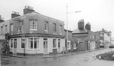
The Criterion public house on
the junction with Victoria Street and Peascod Street, viewed
from the original (and genuine) Cross's Corner. (Ref. no.
16, see below)
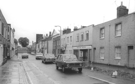
Victoria Street looking east
towards the junction with James Street on the left. (Ref. no.
12)
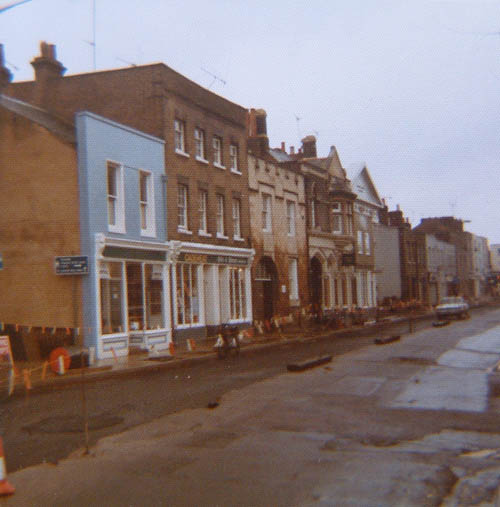
The southern side of Victoria
Street, by the junction with William Street,
14 February 1975, with major road resurfacing work.
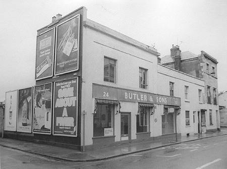
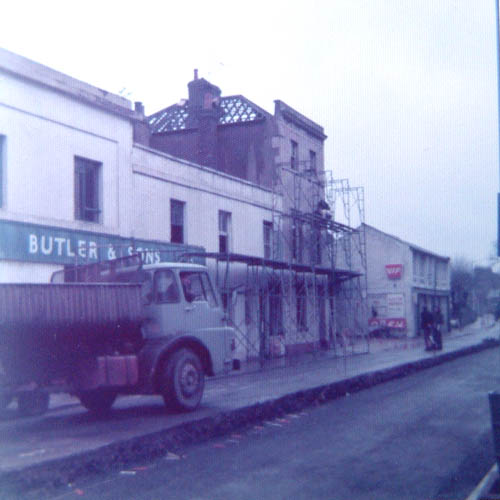
Butler & Sons,
hardware dealers, on the junction of Victoria Street, to the
right, and James Street, left. (Ref.
no. 01)
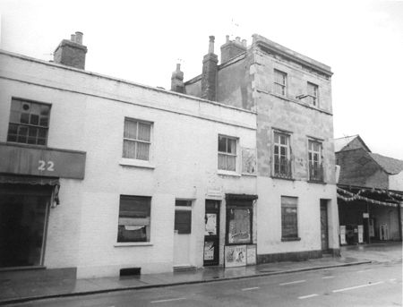
No. 22 Victoria Street with the
small premises belonging to T F Pardoe, shoe repairers. (Ref.
no. 02)
The northern side of Victoria
Street looking towards Barker's Garage on the junction with William
Street. 14 February 1975 with major road resurfacing taking place
in Victoria Street
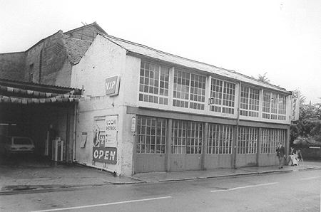
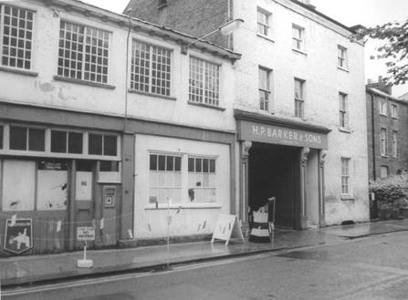
The well-known building at the
junction of Victoria Street and William Street, the premises
of H P Barker, one time Volkswagen and later, Mazda, sales
and repairs.
Petrol was sold from the forecourt
to the left. Barker's premises were hit by an oil bomb during
WWII. (Ref. no. 03)
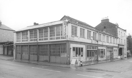
Another view of Barker's from
across Victoria Street, looking towards William Street. (Ref.
no. 04)
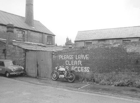
Barker's entrance in William
Street. (Ref. no. 05)
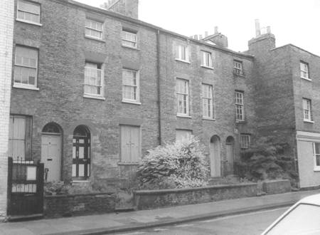
From left to right, 37-31 William
Street. (Ref. no. 06)
27-29 William Street in 1974
recorded by Kelly's in 1971 as a veterinary surgery, Bowditch,
Grime & Guthrie. Earlier it had been known as Patterson's.
The veterinary surgery continues in Clewer Hill Road [2007].
(Ref. no. 07)
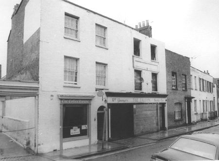
The Coffee House and Falcon 'Hotel',
23 William Street. The Falcon was a not particularly salubrious
bar and bed and breakfast business, and hardly a 'hotel'. (Ref.
no. 08)
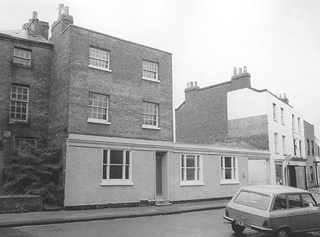
The western side of William Street
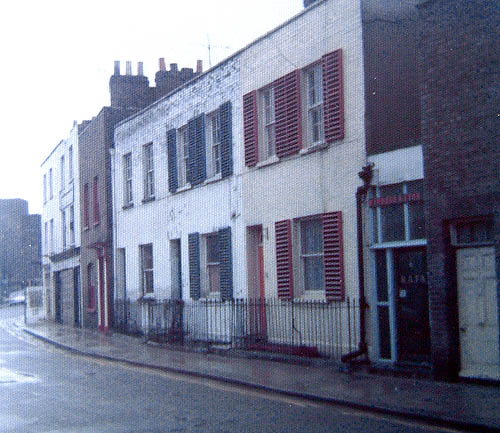
with The Falcon far left, and the RAFA (Royal Air Force Association),
near right, 14 February 1975
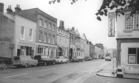
William Street towards the junction
with Peascod Street. (Ref. no. 10)
We have now crossed to the eastern side
of the road and The Congregational Church.
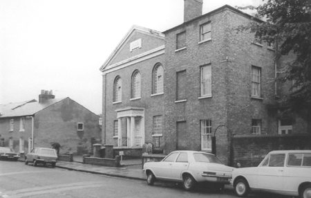
The Congregational Church. (Ref.
no. 9)
The junction of William Street
with Victoria Street, looking west, with Barker's Garage on the
corner. (Ref. no. 11)

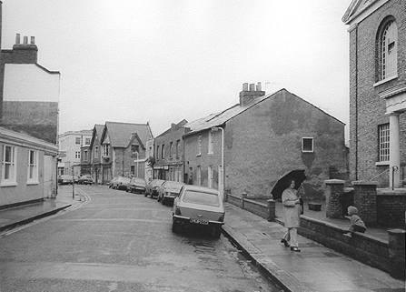
James Street looking east and
south towards Victoria Street. (Ref. no. 13)

Waste land on the eastern side
of James Street used as casual parking. (Ref. no. 15)
The industrial premises at the
far end of James Street formerly used by farriers, House and
Claydon in 1965, though closed by 1974. (Ref. no. 14)
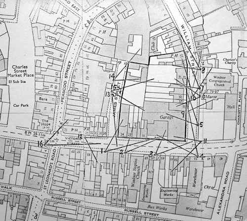
This map features the reference
number of each photograph and the point at which the picture
was taken.
Colour pictures of The
Congregational Church and
surrounding area during demolition in 1978
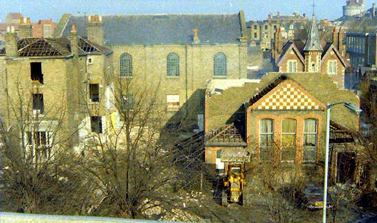
The demolition of the Congregational
Church and nearby buildings in 1978.
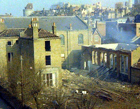
These views were taken from the
multi-storey car park in Victoria Street.
If you would like to comment on these
pictures or if you have any memories do please post them here
on our Discussion
area for William Street.
To contact
us, email Thamesweb.
|
A photographic
record of
William Street and Victoria Street
Also James Street, 1974-1975
William Street and Victoria Street
Also James Street, 1974-1975
In 1974 plans had been agreed to demolish Barker's Garage and the surrounding buildings in Victoria Street, William Street and James Street to construct modern offices together with a supermarket, underground car park and a club. The supermarket was to be built on two levels above the underground car park. This photographic record was created shortly before demolition started, hence a number of the premises are boarded up. We were pleased to discover these views especially of Barker's Garage which was a typical example of a coach builders workshop of Victorian times.
In 1977, following redevelopment, the supermarket area was occupied by International Stores and in 1989 was trading under the Safeway brand.
The photographic 'tour' commences at The Criterion in Victoria Street, progresses to the Barker's Garage at the William Street junction, takes a look at the buildings in William Street, then returns to Victoria Street and James Street, a short 'no through road' on the north side of Victoria Street. Each photo has a reference number which tallies with a reference number on a map at the end of the article, showing the location of each view.
In September 2009 additional photographs were located, in colour, and these have been included adjacent to the earlier mono images. The pictures were taken on a rather dull day on 14 February 1975.
The Criterion public house on the junction with Victoria Street and Peascod Street, viewed from the original (and genuine) Cross's Corner. (Ref. no. 16, see below)
Victoria Street looking east towards the junction with James Street on the left. (Ref. no. 12)
14 February 1975, with major road resurfacing work.
Butler & Sons, hardware dealers, on the junction of Victoria Street, to the right, and James Street, left. (Ref. no. 01)
No. 22 Victoria Street with the small premises belonging to T F Pardoe, shoe repairers. (Ref. no. 02)
The northern side of Victoria Street looking towards Barker's Garage on the junction with William Street. 14 February 1975 with major road resurfacing taking place in Victoria Street
The well-known building at the junction of Victoria Street and William Street, the premises of H P Barker, one time Volkswagen and later, Mazda, sales and repairs. Petrol was sold from the forecourt to the left. Barker's premises were hit by an oil bomb during WWII. (Ref. no. 03)
Another view of Barker's from across Victoria Street, looking towards William Street. (Ref. no. 04)
27-29 William Street in 1974 recorded by Kelly's in 1971 as a veterinary surgery, Bowditch, Grime & Guthrie. Earlier it had been known as Patterson's. The veterinary surgery continues in Clewer Hill Road [2007]. (Ref. no. 07)
The Coffee House and Falcon 'Hotel', 23 William Street. The Falcon was a not particularly salubrious bar and bed and breakfast business, and hardly a 'hotel'. (Ref. no. 08)
The western side of William Street with The Falcon far left, and the RAFA (Royal Air Force Association), near right, 14 February 1975
We have now crossed to the eastern side of the road and The Congregational Church.
The junction of William Street with Victoria Street, looking west, with Barker's Garage on the corner. (Ref. no. 11)
Waste land on the eastern side of James Street used as casual parking. (Ref. no. 15)
The industrial premises at the far end of James Street formerly used by farriers, House and Claydon in 1965, though closed by 1974. (Ref. no. 14)
This map features the reference number of each photograph and the point at which the picture was taken.
Colour pictures of The
Congregational Church and
surrounding area during demolition in 1978
If you would like to comment on these pictures or if you have any memories do please post them here on our Discussion area for William Street.
To contact us, email Thamesweb.