Maidenhead, Windsor
& Eton Flood Alleviation Scheme
Background Notes
(Pre-Construction)
1. Introduction
The towns of Maidenhead, Windsor and Eton
and nearby villages have a very long history of flooding from
the river Thames. The threat still exists. Flooding will occur
again and again in this area unless some scheme of alleviation
is implemented.
2. Last Major Flood
This area floods about once in five to
seven years and there was a flood of this magnitude in 1990,
which affected around 500 homes. The last major flood occurred
in 1947 and had a return period of 1 in 56 years. If a flood
of this size were to happen today it is estimated that over 5,500
properties (and consequently over 12,500 people) would be affected
at a cost of £40 million.
The major roads in this area, including
the M4, would be closed and electricity, telephone and other
services would be interrupted. This would affect countless other
people and would have an adverse effect on the local economy.
Which in turn would affect the national economy.
3. History of The Scheme
Thames Conservancy
After the 1947 flood, there was a lot of
public pressure on the relevant authorities to do something to
stop a similar flood happening. The Thames Conservancy was the
relevant authority at that time, and they investigated the problem
and produced a summary report. The Chief Engineer of the Conservancy
recommended to the Board that planned zones should be established
along the length of the river in which new development should
be prohibited and existing development be demolished when it
came for sale.
These recommendations were accepted and
the local planning authorities took
appropriate action by amending their County Plans. In December
1954 Maidenhead flooded again. This time it was as a result of
the Maidenhead Ditch overflowing and not the river Thames. The
Conservancy decided to undertake flood alleviation works in this
area by increasing the capacity of both the Maidenhead Ditch
and The Cut. They also reconstructed a bridge north of the Maidenhead
Ditch so that when the flow in the Maidenhead Ditch reached its
capacity, the bridge would restrict any more incoming flows and
store excess water in a pond area in North Town Moor.
These works which have a capacity for a
one in ten year return period flood were intended to stop a repeat
of the 1954 flood only, and were not undertaken to solve the
overall flooding problem in Maidenhead.
Thames Water Authority
In 1973 when the Water Authorities were
formed, they were required by law to
undertake surveys in respect of flooding and land drainage. From
these surveys, the Maidenhead flooding problems were identified
and strategies developed for possible solutions.
There are flooding problems along the whole
length of the river Thames, but it was considered impossible
to solve the problems along the whole length in one go. The Maidenhead
area was identified as needing priority action because of its
history of repeated flooding and where money spent would produce
the greatest return in damage avoided.
Thames Water Authority appointed a specialist
firm of consultants to investigate the flooding problem and also
what would be the likely benefits of various options of flood
alleviation schemes. They identified that there would be considerable
benefits if the flood damage could be avoided and that it would
be possible to alleviate flooding in this area.
Following this report, consultants working
on behalf of Thames Water Authority undertook exhaustive studies
of the complex and interrelated engineering and environmental
considerations of various flood alleviation schemes. Local authorities
and other interested organisations and individuals were consulted
extensively and their responses were taken into account. All
possible options were considered so that the scheme chosen was
the most appropriate method of meeting flood alleviation in this
area.
In January 1989, the Thames Regional Land
Drainage Committee agreed to seek planning permission for the
Scheme chosen and in March 1989 they agreed To extend the Scheme
to provide flood protection for Windsor and Eton, and not just
Maidenhead.
National Rivers Authority
The National Rivers Authority took over
the work of Thames Water Authority when it was formed in September
1989 and continued to investigate and develop the Scheme.
The present Project Team was appointed
in September 1989 with a brief to obtain planning permission
by negotiation, if possible. Unfortunately it was not possible
and a local Public Inquiry was set up in 1992.
The Scheme finally received approval from
the Secretary of State in 1995,
Environment Agency
The Environment Agency is the statutory
successor to the National River Authority, Waste Regulation Authorities
and Her Majesty's Inspectorate pollution. The Agency has inherited
all flood defence duties from the National Rivers Authority and
this includes constriction of the Maidenhead, Windsor and Eton
Flood Alleviation Scheme.
4. Options Considered
All methods of flood relief were considered
including storage, dredging and embankments before it was decided
that the best option was to construct a Flood Relief Channel.
Over 492 possible combinations of routes were examined and evaluated,
and local authorities and other interested organisations and
individuals were consulted, and eventually the present route
and design were adopted.
The channel solution was selected on the
basis of providing a minimum protection for the area of I in
65 years flood event standard. At this level of protection the
other possible options of flood alleviation were not practicable
for various reasons: flood storage schemes would have needed
an area the size of Oxfordshire to accommodate all the water;
large flood levees along the edge of the river would not have
been possible environmentally; dredging would have been disruptive
and would have to be done continuously to maintain the required
capacity.
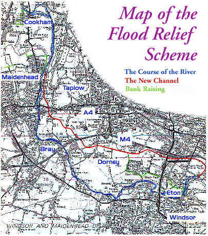
5. Scheme Description
The Scheme takes the form of a flood relief
channel, some localised bank raising close to the river and improvements
to the existing flood relief channel, through Maidenhead, The
Maidenhead Ditch.
The channel runs along the east side of
the river Thames, leaving the river at Boulter's Weir in North
Maidenhead and rejoining at Black Potts Viaduct just downstream
of Windsor, It has a trapezoidal cross-section that is unlined
with a bottom width of about 30 m. The side slopes are 1 in 1.5
and average depth is 5 m so that for most of the route the channel
is 45 m wide.
Natural Design
The channel has been designed to look and
function as a natural living river, containing water all year
round, and will be landscaped sensitively to enhance the environment
and create new habitats in what is currently a relatively ecologically
uninteresting area. The Environment Agency will also recreate
habitats that have been lost from the river Thames over the years,
as a result of river-side developments.
As a consequence of the high emphasis placed
on environmental design, the Scheme has gained support from both
national and local environmental groups.
Operation Under Flood
Conditions
The river Thames in this area can accommodate
a flow of about 285 m3/s. Above this level the excess water will
overflow the banks and fill the flood plain.
The channel takes the excess water flow
from the river Thames. The amount of water allowed down the channel
will be controlled by radial gates near Taplow Mill.
The channel and the river Thames together
will be able to accommodate a flow of about 515m3/s with the
Flood Relief Channel carrying 215m3/s. This will protect the
area from floods with a return period of I in 65 year period,
a greater intensity than the 1947 flood. It will also substantially
reduce the impact of greater events.
Normal Operating Conditions
The channel will have running water all
year round. The water will be supplied naturally from the ground
water table and a small flow of about 10 m3/s taken directly
from the river Thames.
Water levels within the channel will be
regulated by control structures and these will be set at a level
to ensure that existing ground water levels are maintained within
the area.
6. Public Inquiry
Because of the regional significance of
the Scheme, and the inability of one of the local councils to
resolve the matter, the planning application was called for Public
Inquiry in 1992.
The Inquiry opened on 1 October 1992 and
closed at the end of December 1992. Even so it was not until
March 1995 that approval was finally given.
Inquiry Assessor's Recommendation to the
Secretary of State:
"My overall conclusion is that the Scheme described in the
Planning Application is a good technical solution to the flooding
problem which no other option can match".
The Inquiry Inspector stated:
"Furthermore, I find that the evidence strongly suggests
that the Scheme would be a uniquely attractive addition to the
landscape between Maidenhead and Windsor.
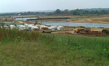
7. Soil Disposal
Whilst the finished Channel will be a quiet
and pleasant addition to the local scene, its construction will
cause considerable local disturbance for a limited period of
time. The major challenge will be the removal of excavated material,
principally minerals, from the site. The majority of this material
will be taken directly along the line of the channel to a processing
plant and then on to the M4 Motorway via Junction 6; material
from the two end sections will be removed by barges on the Thames.
This will avoid any use of local roads for other than construction
traffic to specific sites.
Since the granting of the Planning Approval
the minerals industry has been working hard to find ways of accommodating
3.5 million tonnes of mineral from Maidenhead in 31/2 years whilst
at the same time Eton College are producing 4.5 million tonnes
over a period of 11 years into a contracted market which is already
fully supplied.
Many of the solutions allow for long term
storage of material and various potential contractors have obtained
planning permission on various sites for importation and storage.
There is planning permission to install
a rail siding on the site of the gravel processing plant and
permission for a conveyor to bring mineral from Area Nine to
the rail terminal.
This option is strongly favoured on environmental
grounds and carries the possibility of receiving a Government
Grant to enable the environmental benefits to be realised in
the face of possibly adverse financial factors.
Sale of the minerals will go some way to
offset the cost of constructing the channel although the Treasury
have insisted it is not an economic gain and all reference to
the sale of minerals has been omitted from the benefit/cost assessment
approved by them.
8. Cost
The estimated gross implementation cost
of the Scheme is £83.5M including a projection of inflation
at 3% to the end of the construction period. This sum will be
offset by money arising from the sale of minerals. The Scheme
is designed to alleviate flooding of some 4,800 private properties,
benefiting some 12,500 people, 700 commercial premises and major
infrastructure - for example the M4 - that would be at risk.
Benefit/Cost Analysis
The estimated gross implementation cost
of the Scheme is £83.5M including a projection of inflation
at 3% to the end of the construction period. This sum will be
offset by money arising from the sale of minerals. The Scheme
is designed to alleviate flooding of some 4,800 private properties,
benefiting some 12,500 people, 700 commercial premises and major
infrastructure - for example the M4 - that would be at risk.
The tangible benefits arising from the
Scheme, discounted at 6% to 1992, are £52.728 million.
The implementation and maintenance costs
of the Scheme over its designed life of 65 years, again discounted
to 1992, are £43.738 million.
Thus the Benefit/Cost Ratio is 1.21:1
When intangible benefits are added at 25%
the figure becomes 1.4:1
This very robust figure has been accepted
by the Ministry of Agriculture, Fisheries and Food but the inclusion
of recreation and amenity benefits and benefits from the sale
o minerals has been disputed by the Treasury. Nonetheless, even
with these excluded the ration is 1.07:1 which is just about
satisfactory.
|