 Updated 17th May 2004
January 2003 Floods
and Jubilee River
Bank Collapse
Since January 2003 there
has been increasing concern about the condition of the Jubilee
River and its operation before and during the flooding. A number
of residents downstream have actively campaigned for the truth
to be published about the Jubilee River at that time and its
overall effectiveness. This article illustrates some areas of
erosion that occurred when the flood relief channel was first
used. Letters highlighting residents concerns since the floods
are included here in the Windsor Forum. You are welcome to contribute too.
Background
Over the New Year of 2003
and possibly as early as Christmas 2002 signs of erosion were
appearing along the banks of the Jubilee River, before it was
used in earnest during the floods that occurred in the first
week of January 2003. The picture below shows significant erosion
at a bend in the bank, with white water flowing towards it. Had
the bank failed at this point water would have flowed through
to fields to the right towards Eton Wick.
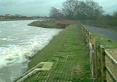
The picture above was taken
on January 2nd 2003 (16.39) and clearly shows a high rate of
water flow adjacent to the weir and the damaged bank beyond.
Environment Agency workmen had already erected a temporary orange
warning barrier where the fence and river bank had slipped into
the water.
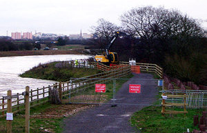 The next day contractors had arrived
to shore up the bank
The next day contractors had arrived
to shore up the bank
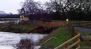 Bank erosion being temporarily
repaired at Manor Farm Weir.
Bank erosion being temporarily
repaired at Manor Farm Weir.
(With thanks to P. Bragg for the pictures above)
Phil Bragg writes:
It started before Christmas.
The path was initially left open with some orange mesh guiding
pedestrians and cyclists to one side, over the Christmas period,
but by Jan 2nd the path was closed with metal barriers. Soon
after this, stabilisation work commenced with large sand bags
and rocks to build up the "dry" side of the bank.
A few days later I took a few pictures and spoke
to a senior chap from the Environment Agency. He said it was
a major engineering project and that the path would not be reopening
until permanent repairs were done in the Spring. He apologised
for the lack of a cycle path. This was about the 4th January.
There was just one small
crane dropping the large bags of sandbags and rocks down to some
people who were positioning them. The next day there were many
more cranes and two dump trucks, with lorries delivering more
materials.
At one point
it seemed that they had opened a footpath on the opposite side
of the river but this was closed when the bank eroded in a similar
fashion.
By January
24th the temporary repairs seemed to be complete, but the path
was still closed, along with a good portion of the hilly part
of the landscaping. Access was still possible from Dorney Common.
The pictures
are not good as the light was poor and I was a long way off,
using full zoom!"
A phone call to the Environment Agency
at the time confirmed the above. Local rumours about an imminent
bank collapse and that the flow to the Jubilee River was deliberately
restricted to lessen the erosion, were denied by the EA spokesman,
however subsequent reports that we have seen confirm that the
diverted flow to the Jubilee River was deliberately restricted
to 144 cumecs (cubic metres per second) whereas, in the conditions
that existed at the time, a flow rate of 200 cumecs would have
been expected. The Jubilee River's capacity is claimed to be
215 cumecs. It has been alleged that some housing in Eton Wick
would have been threatened in the event of a bank collapse.
 Bank erosion at the start of the
Jubilee River at Mill Lane is still evident in July 2003
Bank erosion at the start of the
Jubilee River at Mill Lane is still evident in July 2003
 Bank erosion downstream at Mill
Lane, photographed in July 2003. North bank.
Bank erosion downstream at Mill
Lane, photographed in July 2003. North bank.
 Bank erosion downstream at Mill
Lane, photographed in July 2003. South bank.
Bank erosion downstream at Mill
Lane, photographed in July 2003. South bank.
In late 2003, repairs were being made along
the banks of the Jubilee River with some path closures. In October
2003 work was still in hand at Mill Lane strengthening the banks
illustrated above.
It remains to be explained why so much
damage was done to the banks of the Flood Relief Channel almost
from the outset.
Update May 2004
On May 18th 2004, a Press
Release was issued on behalf of the
local community groups downstream of The Jubilee River. The Press
Release is reproduced here in full.
Jubilee
River Exacerbated Flooding
and was known to be flawed before the 2003 Flood Event
- ENVIRONMENT
AGENCY KNEW ABOUT SERIOUS EROSION PROBLEMS WITH JUBILEE RIVER
BEFORE 2003 FLOOD EVENT BUT OMITTED TO DISCLOSE THIS UNTIL 16
MONTHS LATER - WHEN FORCED TO DO SO
- JUBILEE RIVER
GATES NOT OPERATED FOR NEARLY 3 DAYS AT HEIGHT OF FLOOD EVENT
DUE TO SEVERE EROSION
- WHEN GATES WERE
OPERATED ON 4TH JANUARY, JUST BEFORE MAIDENHEAD WOULD HAVE FLOODED,
LARGE SUDDEN RELEASES WERE MADE WHICH EXACERBATED FLOODING DOWNSTREAM
- The Environment Agency operates
the Jubilee River based on water flow and level target indicators
set out within the operating procedures. Two of these indicators
are tailwater levels at Boulters Lock and a cumecs flow at Windsor
Gauging Station (at Datchet).
- Both of these target indicators
had been exceeded by the 1st January 2003, but following an opening
on the 1st January of the Taplow Sluice Gates the Jubilee River
was not operated for a further three days until the tailwater
level at Boulters Lock had exceeded the target level by some
2ft 4ins (0.71m) and the flow at Windsor had reached 320 cumecs
which is 140 cumecs above the target flow. Only then - on 4th
January 2003 - were the Taplow Sluice Gates operated again.
- At the FRAG Open Day held at
Spelthorne on 27th April 2004 the Environment Agency, under pressure,
admitted the reason for not complying with the operational procedures
and the ministerial directive was due to structural problems
within the Jubilee River and which the Environment Agency had
known about as early as November 2002. This crucial information
had been withheld by the Environment Agency from the public since
the flood event.
- It is understood further problems
occurred at the end of December 2002 and more serious problems
on 1st January when the Jubilee River was operated. These problems
resulted in the Jubilee River not being operated between the
1st and 4th January, well ahead of the flood peak. Had this been
done the extra flow could have been passed on downstream before
the main flood event.
- No reference to this factor
is made within the Mechanisms of Flooding report. Mr Onions'
report does confirm incorrect operation of the Jubilee River
by the Environment Agency but no mention is made to structural
problems of the Jubilee River prior to the flood event. This
is also missing from Mr Onions' Executive Summary, Conclusions
and Recommendations.
- On the afternoon and evening
of Saturday, 4th January large, sudden water releases were made
into the Jubilee River. This was not in accordance with the operational
procedures. These releases commenced after levels had exceeded
13ft 4ins, an old indicator that Maidenhead was about to flood.
It would therefore appear the Environment Agency decided to operate
the Jubilee River to validate £110million spent on the
scheme, knowing that the system was incomplete, not commissioned,
had structural defects, staff were untrained, operating procedures
untested and already invalidated by delay. These large, sudden
releases resulted in:
- Further serious damage within
the Jubilee River watercourse which
was already known to be flawed before the 4th January operation.
- Unnecessary flooding to communities
from Windsor riverside and downstream because water into the
Jubilee River was released too close to the peak of the flood.
The flooding was also exacerbated by loss of the floodplain at
Maidenhead, Dorney and Eton Wick and by the cessation of dredging
since 1993 which reduced the river capacity over time. (This
is stated in the Mechanisms of Flooding Report, Volume 1, 11.3.25)
- Communities, lives and properties
were put at risk by using the Jubilee River watercourse which
was structurally flawed. (This has since been confirmed by the
extent of redesign recommended by the independent consultants,
W S Atkins.)
THE CONCLUSION DRAWN FROM
THE PRECEDING FACTS AND PUBLISHED DATA CAN ONLY BE THAT MISMANAGEMENT
AND MISOPERATION OF THE RIVER BY THE ENVIRONMENT AGENCY PLAYED
A SIGNIFICANT ROLE IN THE SEVERITY OF THE FLOODING DOWNSTREAM
OF THE JUBILEE RIVER
17th May 2004
Repairs required between
The Myrke and Pococks Lane Bridge
Reported in June 2004
 The Myrke to Pococks Lane Bridge
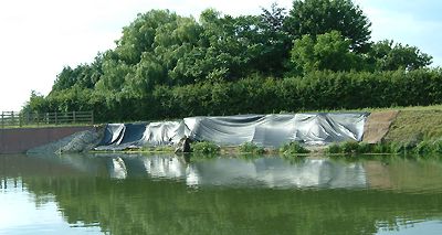
The stretch of the Jubillee River
which is causing concern to downstream residents. Apparently
seepage was noticed through the banks at this point which could
have been a pointer towards a possible breach in severe flood
condition.
 The Myrke to Pococks Lane Bridge
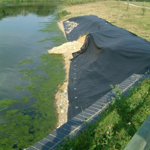
- The ditch behind the embankment
The Myrke to Pococks Lane Bridge
- The ditch behind the embankment
Behind the bank is a ditch which
from a layman's point of view could cause weakness in the banks
themselves
|